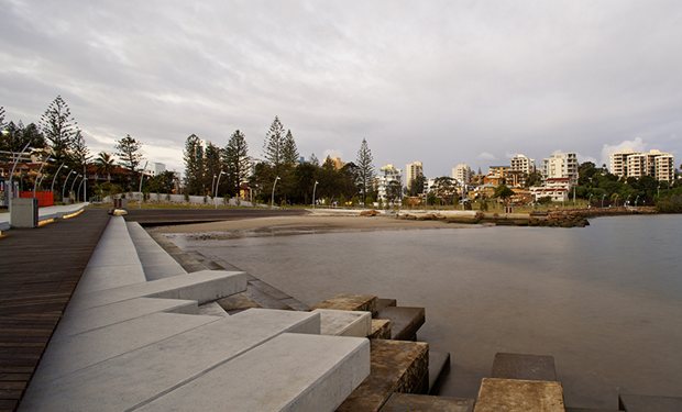
JACK EVANS BOAT HARBOUR - TWEED HEADS (STAGE 1)
ASPECT Studios
The brief called for a recreational and tourism centrepiece for the Tweed Heads town centre. This substantial project delivers key priorities of the Tweed Futures Strategy, The Tweed Heads Economic Development Plan, the Tweed Heads Town Centre Master plan, the 7 year plan, The Tweed Shire City of the Arts 2003-2005 Program and the Place Making & Public Art Policy and will bring about significant social, community and economic benefits regionally to the Tweed Shire.
Whilst the brief called for an accessible beach, the result was a new beach and beach deck, a new rocky headland, an ‘urban pier’, boardwalk, water amphitheatre, swimming areas, fishing points and opportunities for water craft.
The entire waterfront interface has been designed with resilience to cater for changing environmental conditions, frequent tidal variations and intermittent storm surges.
The design responded to sand movements as identified in sediment transport modelling undertaken by Cardno Grogan Richards (project engineers). This involved predicting movements caused by tidal and fluvial fluctuations.
This informed the location of the waterfront elements such as the water platforms and constructed beach
Issues relating to flooding across two municipal and state boundaries were analysed and addressed in the overland drainage design. The design had to address cross border flood modelling issues in another state (QLD) that had differing regulations and standards. These had not previously been dealt with, due to the complexity of the site issues and varying regulations. Accordingly, the project is underpinned by an environmental system response (rather than being limited by territorial boundaries).
INITIATIVES
-
The design responds strongly to withstand 800mm storm surge.
-
To storm surge over time more and more frequency
-
The project has been designed with the ability to be retrofitted in 50 years should that be required
-
Storm water quality objectives were met via gross pollution traps, and exceeded by inclusion of Water Sensitive Urban Design elements such as raingardens and bio swales which were not mandatory.
-
Due to the complex hydraulic condition of the harbour landscape it was necessary to resolve the broader site grading and drainage of the parklands in preparation for future detailed landscape design development; and then to focus on the detail of the harbour edge as a primary objective.
-
The detailed storm water infrastructure treatment involves realigning and relocating outfalls, incorporating gross pollutant traps and establishing bio-swales and rain gardens within open space areas where practical. Accordingly the upgrading of the storm water outlets into the harbour is designed to have beneficial impacts on the overall water quality of the harbour.
-
The provision of concrete platforms, new rock revetment and timber boardwalks have been designed to minimise the natural movement of sand and maintain beaches where practical.
-
The design retains many of the successful and significant tree specimens, and these help ground the new project into its context. The new revetment wall has been designed to facilitate the growth of mangroves.
-
Use of glass fibre composite structural framing (rather than concrete or timber) to decks.
-
The new revetment wall has been designed to facilitate the growth of mangroves.
-
The design of the overland flow of the storm water is visually integrated into the overall public domain upgrades via rain gardens and swales. The major drainage system beneath the space has been upgraded and GPT etc improved to increase the water quality coming into the harbour.
-
The project accommodates for future sea level rise by establishing a new water front promenade at levels which respond to the IPPC’s estimate of sea level rise.
-
Use of glass fibre composite structural framing to the decks. In a study performed by the University of New South Wales, it was found that composite products are more sustainable than their timber counterparts and, across their whole life-cycle, possess a lower embodied energy.
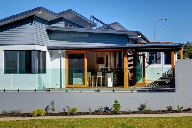
SOUTH SOLITARY
design studio22
The brief was to create a spacious contemporary home, on a sloping 443m2, 14.5m wide lot, with a big focus on sustainability in its design, products and building methods, including on site water.
The home must be designed to take maximum advantage of the entire lot to display as an example for the estate.
INITIATIVES
-
Water - A 22,000-litre rainwater collection tank is buried under the garage floor and provides all water to the house on a priority basis.
-
There is no storage of domestic hot water as detailed above. 98per cent of planting are low water use Australian natives.
-
Resource Efficiency - The site was utilised to it’s full potential and disturbance of waste of soil minimised by stepping the house down the slope and this change of levels also functions to delineate the open plan living areas. The partnership of environmentally aware designer, client and builder created a like mindedness for sustainability awareness in all aspects. Designer is a BDA Eco-Design Smart Sustainable Housing Design Professional and the builder selected is an accredited HIA Green Smart Builder. The designer worked with the builder and owner to select materials and calculate quantities which would minimise waste with only 1.25 skip bins filled throughout the build.
-
99per cent of plantings are low water use Australian natives.
-
The species were chosen because they are suitably sized, adapted to the local conditions of poor soil, salt, wind and high but irregular rainfall.
-
Once established, no irrigation is required.
-
They will assist local biodiversity by providing the most suitable food and shelter for local insects, birds and mammals.
-
By choosing a diverse range of plant species, we offer habitat to a more diverse range of wildlife and enhance the local environment and habitat. Greensmart practices adopted throughout; 95per cent lighting LED, bal compact fluorescent.
-
Low E glass; Lowest emission, highest efficiency wet back slow combustion with 3.7kw hot waterheat exchanger; 95 metres/6 zones of in slab hydronic heating on south.
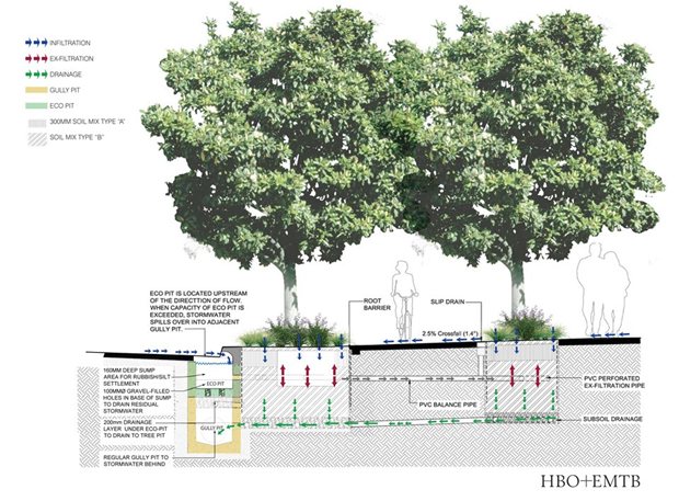
MULTIPURPOSE ECO-GARDEN
HBO+EMTB
This project is the result of a partnership between the Blue Mountains City Council, the Roads and Maritime Services and multi-disciplinary design house HBO+EMTB. Together the project team has transformed a highway upgrade project into an example of Water Sensitive Urban Design (WSUD).
The local Council and community were concerned that recent infrastructure developments in Lawson would significantly increase the impervious ground surface areas with consequent modification of the hydrology, drainage, stormwater quality, ecosystem health and water cycle.
All stormwater from the city flows directly into the World Heritage National Park, making the receiving environments vulnerable to ongoing stormwater pollution and damaging changes to stream hydrology. These stormwater and environmental issues had the potential to pose a threat to the World Heritage area and specifically the downstream endangered hanging swamps.
INITIATIVES
-
Water Quality Improvement: This design aims at capturing the first flush and recycling it through the subsoil tree feeding system. The innovative system exceeds the minimum water quality targets of a typical soak-away, rain garden/bio-retention basin, infiltration pit and groundwater recharge system by using specially graded soil horizons and a deeper media.
-
Water Quantity Detention: The runoff captured in the three eco-pits is continuously feeding through a 200m long exfiltration spiral system and soak-away through the gravel. The continuous system reduces the runoff leaving the site and the flooding risk to the receiving catchment.
-
Placemaking: Drainage at the base of the tree pits flow back to gully pits and also introduces aeration at a depth which makes it possible for tree roots to fill the entire soil volume, allowing larger tree species to achieve their full growth potential providing landscape / township features.
-
Environmental issues: Extensive native landscaping along the highway will integrate the manmade landscape with the surrounding park, as well as provide a green corridor for fauna in the local vicinity. The captured runoff will provide alternate irrigation waters to the streetscape and reduce potable water consumption. This system will improve the hydrology, water quality and public health of the local environments.
-
Flood Mitigation and Drainage: The system reduced peak flow to the receiving catchment, reducing erosion and flood risk.
-
Streetscape: Extensive landscaping and urban design initiatives have enhanced the character of the shops, service road and reduced the visual and noise impact from the Highway.
-
Microclimate Improvement: Extensive native landscaping using large trees along the highway will improve the amenity of the township.
-
Alternate Water Sourcing: The runoff from the footpath, carpark and service road will supply alternate irrigation waters to the streetscape and reduce potable water consumption.
-
Water Quality Improvement: The eco-pits improve stormwater quality, particularly catching first flush from the carpark. This system removes suspended solids, excessive nutrients and other pollutants from reaching the downstream native bushland.
-
Infiltration and Dissipation of Runoff: The unlined system will reduce runoff by allowing the filtered stormwater to infiltrate to the subsoil. The gravel drainage layer at the bottom of the leaky system allows stormwater to dissipate to the subsoil, reducing runoff and flood risk.
-
Protection of endangered species: Endangered native hanging swamps in the Blue Mountains require constant recharge to the groundwater. Infiltration allows rain water to reach and saturate the downstream endangered hanging swamps, improving environmental values of the World Heritage area.
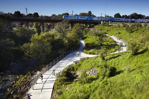
JEAVONS LANDSCAPE ARCHITECTS
Clifton Hill Rail Project
The duplication of the railway track between Clifton Hill and Westgarth Stations was a key public transport initiative to improve Melbourne’s public transport service, requiring a second rail bridge to be constructed over the Merri Creek (bridgework completed in 2009).
Jeavons Landscape Architects were responsible for implementing a complex landscape architectural brief for the landscape planning and design of green infrastructure along the new track and in the adjoining Merri Creek corridor.
The project required the blending of technically challenging design with aesthetics and high community expectations, including:
Addressing the engineering and operational requirements for the railway and co-ordination with multiple authorities, two local councils, Melbourne Water, and numerous road and rail authorities
INITIATIVES
-
Managing impacts on the Merri Creek corridor including visual impact, recreational trails, natural values, flood flows
-
Restoration of the indigenous creek vegetation and environment, dealing with runoff
-
protection of Aboriginal and non indigenous heritage values (original bridge is heritage listed)
-
Functional and amenity considerations such as pedestrian and cycle routes, design of the interface between the railway and local streets, fully accessible pedestrian crossings over the tracks, viewpoints, safety & sightlines; cycleway signage.
-
Design of a complex intersection on the capital city bike path up a steep slope , advocacy for open space and design of a new small park under the bridge (Bridge Park)
-
Temporary re-routing of cycle networks, and creation of works plans to ensure runoff and the impact of site works were minimised during construction.
-
Merri Creek biodiversity restored
-
The design sought to recreate locally indigenous flora communities of similar species composition and structure to the original ecology.
-
Over 48,000 local indigenous plants were installed after rigorous research.
-
The design approach incises natural vegetation layers with sinuous walls and paths that merge with the organic landforms. A major staircase structure on the south bank cascades down the slope, its basalt sides and angular corten panels evoking the blocky forms, and textures of the basalt cliffs of the valley. The design concept is expressed eloquently in the built form as follows:
-
Restoration of the natural environment with indigenous species and ecological structure based on published research guidelines for the Merri creek valley.
-
The existing heritage listed rail bridge and railway context are reflected and expressed in the landscape through raw materials– corten steel, bluestone slabs and railway ballast gabions.
-
The vegetation composition is tailored to suit each micro-climate from the water’s edge and lower slopes, through the mid-slope, top of slope, cliff-face and grassy woodlands. Our designs are based on the DSE’s ecological vegetation classes, recent research by ARCUE and recommendations of the Merri Creek Management Committee.
-
Bluestone emerged as a significant material, reflecting both natural and social history. As the natural site bedrock and the traditional streetscape material, the sawn, vertical bluestone slabs with broken ends reflect the local basalt cliff-faces provide a contemporary twist and also meet local heritage requirements.
-
Making use of ‘broken’ seconds unusable for Melbourne’s footpaths, these are an especially sustainable, durable material quarried and sawn in Victoria. Basalt also features crushed as railway ballast in the feature gabion walls, and as mulch.
